Roads and buildings
The 242-Foot Bridge on the Warren County Bikeway
Series date: · 3 min read
Prepared and first published . About these dates
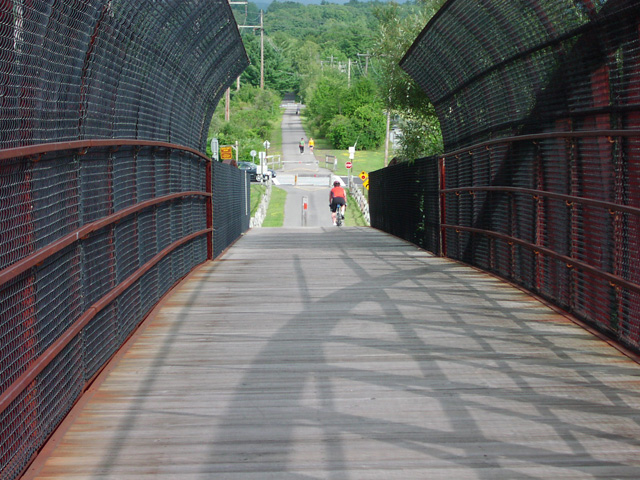
A 242-foot prefabricated truss bridge carried the Warren County Bikeway across Quaker Road. The county's history describes its purpose as connecting walkers and cyclists to the northern part of the trail without making that crossing at road level.
Its dedication to Gerald B. Solomon on June 17, 2000 is one event in a longer construction history. The rail corridor, the trail's successive sections and the bridge dedication have different dates. Keeping them separate explains how the route came together. [1] [3]
Where the bridge fits in the four phases
| Phase | Dates stated | Section described |
|---|---|---|
| First | 1978 | Glenwood Avenue north to State Route 9 |
| Second | Work began in fall 1978; completed in 1979 | Bloody Pond Road to Fort George |
| Third | Added in 1999 | Quaker Road to Cooper Street, with a bridge connecting toward the northern section |
| Final | 2000 | Leonard Street to Platt Street in downtown Glens Falls |
This table follows the county's named phases, not a freshly surveyed alignment. The sequence shows why a bridge and a final trail section can appear in the same broad period without sharing a single opening ceremony. The historical description supplies the bridge's dedication date separately. The archived bridge photograph adds a view of the crossing, while the archived trail maps put the linear route in its wider setting. An image can show the structure; the phase account explains the link it was meant to make.
The older corridor led toward trains and steamboats
The county history traces the bikeway's origin to a Delaware & Hudson Railroad branch constructed in 1882. The branch connected at Fort Edward and ran north to Lake George. Its Lake George terminus put travelers near the steamboat departure point. [1]
Train schedules in the account were arranged around lake-boat departures and arrivals. That historical transport connection helps explain the corridor's destination. It does not mean the modern trail precisely follows every part of the former railway or that its present access points match old station entrances.
Railway origin and trail construction should therefore appear as two layers. The first tells why a corridor existed. The second records how sections were assembled for walking and cycling.
The Quaker Road bridge belongs to the latter task.
What the dedication tells us
The county's account identifies Solomon as a Queensbury native who served on the Warren County Board of Supervisors and later in the House of Representatives. It dates the dedication of the bridge to June 17, 2000. This provides a named event for the structure rather than an assumed construction date inferred from a photograph. [3]
Its prefabricated truss form and its stated 242-foot length are also part of the description. The source reviewed here does not give the contract price, the manufacturer or an account of the installation. Those details should not be supplied from a generic explanation of how similar bridges are built.
A bridge can be necessary to connect trail segments without making the whole route free of road crossings. The county's broader bikeway description says some portions use or intersect local roads where a separate trail was not possible. The one crossing illustrated here cannot establish the conditions of every other section.
A simple way to read the connection
- Identify the corridor: the former railway provides the older northward connection toward Lake George.
- Locate the sections: use the phase descriptions and maps to distinguish work completed in different years.
- Find the road barrier: Quaker Road is the crossing addressed by this particular bridge.
- Keep the dates attached: the bridge dedication and the final downtown section are separate entries in the 2000 history.
The restored bikeway page retains the full account and links to its maps. The modern county page provides another point of reference, but this article is about the construction sequence rather than a statement of current trail conditions.
In the account, the final downtown section is described as completing the 9.4-mile bikeway in 2000. The Quaker Road photograph records a specific piece of that connection: a truss crossing dedicated on June 17.
Sources and archived records
- Warren County BikewayRailway and bikeway construction history. Checked October 23, 2026.
- Archived bikeway bridge photographHistorical county photograph; shooting date not established. Checked October 23, 2026.
- Warren County BikewayCounty bikeway history; publication date not stated. Checked October 23, 2026.